Assessment of Riparian Restoration Potential on the Lower Gila River
Location
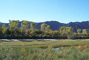
Lower Gila River, Arizona
Client
The Nature Conservancy
Project Description
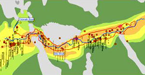
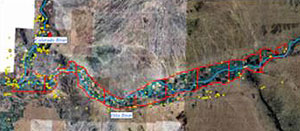
GSA completed an assessment of the potential for riparian restoration projects throughout a 200,000-acre segment of the historic Gila River floodplain, upriver of Yuma, Arizona.
We reviewed all restoration projects in the area to determine lessons learned and identify challenges and opportunities for restoration success. Primary limiting factors identified were groundwater depth, groundwater and soil salinity, and prevalence of wildfires.
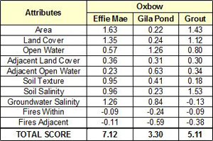
Ecologically-relevant GIS data available for study area were compiled, including existing vegetation and open water, soil texture and salinity, groundwater salinity, fire frequency and size, adjacent land use, and site access, were used to construct a Multiple Accounts Analysis and rank river reaches for restoration feasibility. Specific areas of interest, such as historic restoration sites, remnant native vegetation, and historic oxbows were then assessed and ranked based on GIS data layers. A list of sites was recommended for on-the-ground assessment.
Project Highlights
- Literature review of restoration challenges and lessons learned in the project area
- Historic GIS data accumulation and analysis
- Geodatabase development
- Multiple accounts analysis to rank potential on reach and sub-reach scales